Some facts about the Sunnyside neighborhood:
- Founded as a district in 1891 by the Sunnyside Land Company.
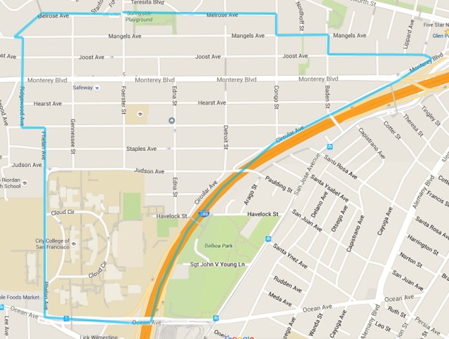
- Located in south-central San Francisco, between City College of San Francisco and Mount Davidson, with Mission Terrace, Glen Park, and Westwood Park as nearby neighborhoods.
- About 2800 households and about 6000 residents, about one mile by one-half mile in size.
- Part of both District 7 (Supervisor Myrna Melgar) and District 8 (Supervisor Rafael Mandelman).
- Schools: Sunnyside Elementary School (SFUSD) and Saint Finn Barr School (Catholic) and nine preschools, including Miraloma Cooperative Nursery School.
- Parks: Sunnyside Playground and Dorothy Erskine Park, with Balboa Park nearby.
- Home to Sunnyside Conservatory, City Landmark.
- Served by two BART stations: Glen Park BART and Balboa Park BART.
- Served by three Muni bus lines: 23-Monterey, 36-Teresita, and 43-Masonic [pre-covid].
- SF Planning Dept. places it in the Outer Mission Neighborhoods Group.
- Has walkability score 78 on Walkscore, with 80/Transit and 64/Bikability
- Just call it “Sunnyside” (not “The Sunnyside”)
Below is a historical summary and description.
Some Neighborhood History
Sunnyside was laid out for residential development by a private real estate investment company called Sunnyside Land Company in 1891. The generally south-facing hillside of the area lent itself to the name ‘Sunnyside,’ which was at that time also a popular name for other neighborhoods, such as in Marin and Santa Cruz. Before that the land was part of the Rancho San Miguel, providing pasture for dairy animals and land for some farming.
The man who founded the land company was Behrend Joost, a German-born hardware entrepreneur and real-estate investor. His great claim to fame was starting San Francisco’s first electric streetcar, the San Francisco and San Mateo Electric Railway. He was indeed far-seeing; soon electricity was running most of the streetcar lines in the city. Sunnyside was one stop on the line, and the railway provided the primary connection to the rest of the city for the new neighborhood. Yet it remained sparsely populated for years.
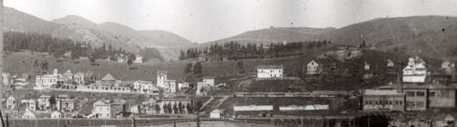
After the Earthquake and Fire of 1906, development picked up a bit, and more people moved out to the neighborhood, as happened elsewhere in the city. But not until the building boom of the 1920s did the blocks begin to fill out and business on the main thoroughfare Monterey Boulevard picked up. Still, many of the hillier streets remained undeveloped until 1950s.
There are mix of house styles, with a few Victorian cottages interspersed among a much larger number of modest mid-century four- or five-room homes, including Mediterranean Revival. [More history in Links section below.]
Neighborhood Features
Sunnyside is a medium-sized neighborhood that is bordered by Interstate 280 on the south-east, Glen Park on the east, Miraloma Park to the north, and Westwood Park/Highlands to the west.
To the south is the main campus of City College of San Francisco (CCSF), which is officially part of the neighborhood. CCSF was built on a hillside formerly occupied by the City jail until the 1930s. The college has been extensively remodeled and modernized since 2000 and offers superior sports facilities, modern buildings, BART and MUNI access, and is the largest community college in the United States.
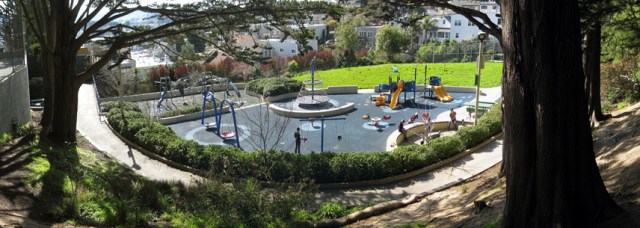
On the north edge is Sunnyside Playground. Built in the 1960s, this beautiful park has great views, a basketball court, tennis courts, a clubhouse with local programming from Recreation and Parks Dept, and a new children’s play area, having undergone many improvements in the 2000s.
Sunnyside’s primary shopping street is Monterey Boulevard, from Edna Street to Ridgewood Avenue, with small businesses, restaurants, cafes, and a Safeway.
The neighborhood has one beautiful but not well known landmark: the Sunnyside Conservatory.
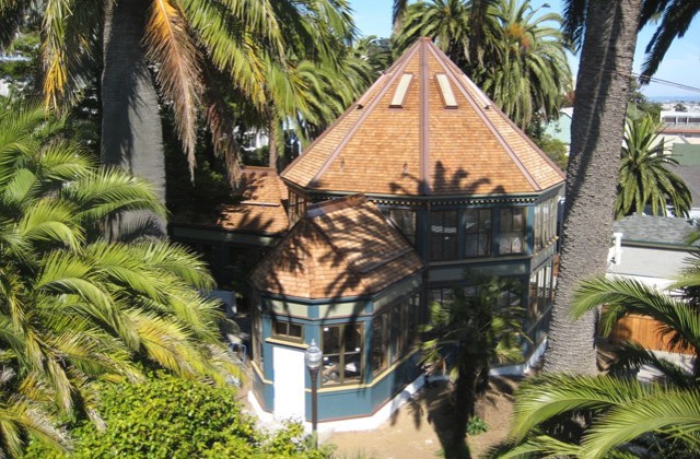
It was built by inventor W. A. Merralls in the early 1900s, but had fallen into disrepair by the 1970s. After being saved from demolition by local residents, it was named City Landmark #78 in 1975, and restored. In the early 2000s it was further renovated with the aid of more extraordinary local effort, and is now managed by the Recreation and Parks Department, which rents it as a location for music events, weddings, and more.
Sunnyside still feels like a working-class neighborhood, despite nestling next to tonier enclaves to the west, such St. Francis Wood and Sherwood Forest. Perhaps because of the topography, and the dead-end streets created by City College and Interstate 280, Sunnyside has always had a somewhat isolated feeling–next to everything, but not a part of it.
The Sunnyside Neighborhood Association
We are the “voice” of Sunnyside. Founded in 1974, the SNA has provided the organizing backbone for local community action and events for more than forty years. Over the decades, the association has taken on a wide range of issues and initiated many changes in local infrastructure, traffic and parking, the environment, and local business matters–as well as organizing fun events for families like the annual Halloween party. Some of the many neighborhood projects included tree planting and traffic calming.
The association has also helped nurture good relations with City College as that important institution has developed and grown. Our District 7 Supervisor is a frequent speaker at our quarterly meetings, as well as other local government figures, law enforcement officials, and city services representatives.
Sunnyside — a good place to live!
Links for more history and information:
- The Sunnyside Conservatory on Monterey Blvd is our premier landmark. http://SunnysideConservatory.org
- A local Sunnyside historian writes a blog about many aspects of Sunnyside’s history: http://SunnysideHistory.org. See >Walks for information about regular history tours in Sunnyside.

Our son and his wife are moving into the neighborhood. Hoping to keep up to date on happenings in their neighborhood!